Where I've Been


View Jeb's Journeys in a larger map
Showing posts with label Stuart Range. Show all posts

Saturday, October 17, 2015

Another week in The Enchantments
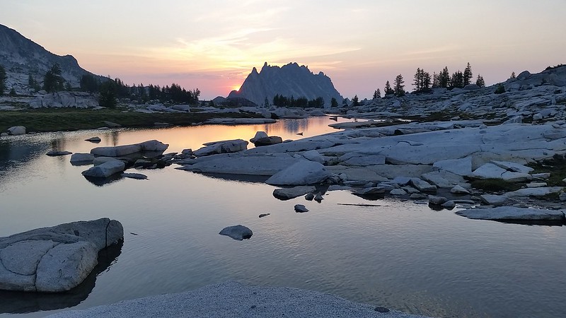
Day 4: The Big Traverse


The lofty, yet realistic goal for the day would be to reach the summit of Argonaut Peak and bivy somewhere below. The pipe dream was to maybe have enough time and energy to continue on to Sherpa. There is very little beta on the Stuart Range traverse available on the internets, but I had pieced together a few helpful tidbits.

I had initially planned for an alpine start, but after discussing a potential timeline we settled on leaving camp at 5. We ascended Dragontail Plateau from south of the ridgeline, crossing only about 200 feet of snow at the saddle. From the west rim of the plateau we located Colchuck Pass and a few potential lines on the east face of Dragontail's SW ridge. We knew that Pandora's Box would be melted out, and my experience with Colin the year before had us highly motivated to avoid it.

The four of us had been to Dragontail so we bypassed the summit, keeping our eyes on the prize. We boulder-hopped down the valley and chose a ledge just south of the pass. Around 200 feet from the top we reached a low 5th class face with a 3 foot wide chimney to the right. We hauled our bags up behind us and found an easy scramble on the other side. A group of three approached Pandora's Box from Colchuck Peak as we started down into the valley. They quickly decided to abandon Dragontail and returned down the Colchuck Glacier.

We filled up on water where the creek passed under a giant boulder. This is where Argonaut came into clear view and the north face seemed to look like a simple scramble. After getting around a 200'+ clean looking vertical to overhung rib I could see that the ramp we had spotted would go. Colin was pretty sure that we would need to lose at least 800' on the other side to reach the south col, and the northern saddle above was so close we couldn't resist having a look. We had, after all, brought rope and a few pieces of pro.

At the saddle we found a great campsite with views of Argonaut's north face as well as Sherpa and Stuart. The ridge up to the north face look surprisingly mellow despite a steep drop off to the north, but some of the route was obscured so I dropped my pack and headed up the ridge for a closer look. The ridge ended in a butter smooth slab above a narrow col. A small ledge below brought me into the col and seemed to continue to a larger system of grassy ramps. If we could get across the col, the remainder of the climb would be simple. Unfortunately it was filled with several feet of 50+ degree hard snow, and about 10 feet wide where we would need to cross it.

I returned with the bad news and we left our killer campsite behind. We happened across another amazing bivy site with plenty of flat sand to accomodate the four of us and even a grassy pillow for a few. We ascended the ledge and found a few options before us. A few hundred feet above and to climbers left was passable terrain and maybe a route to the summit, but Colin was sure that we would need to lose several hundred more feet to avoid getting cliffed out above. Around 500 feet below, we began traversing and Nick decided his blisters would not allow him to continue.

Rob and Nick returned to camp and Colin and I continued on. Thanks to the GPS we could tell that we were on route in the South Col, but Colin was having a hard time recognizing the terrain, which had been buried in 20+ feet of snow when he was there last. We noted a few potentials return routes that may save us some elevation on the way down. We ascended clean white ledges with a few sketchy moves here and there, and soon enough we were just below the summit looking up at the rap station. We climbed up a very fun chimney choked with chock stones and then inched around an exposed ledge before the final scramble to the top.

It felt great to finally reach the summit, after starting our journey nearly a year ago. We looked down at the ridgetop camp, and half-considered exploring a route down to avoid the extra elevation loss the way we had come. After a short discussion we agreed that we would be better off exploring the higher traverse that we had considered on the south side. We managed to find workable route which saved about 400 feet, but we did opt to rappel down one 40' pitch of low 5th class rock along the way. Colin radioed ahead and as we rolled back into our bivy site just before sunset we were greeted with fresh hot water for dinner.
20150710_052643

Friday, December 5, 2014

2014-11-30 Bean Peak, plus Marys and Judis


Colin and I decided to take advantage of the decent weather forecast for Thanksgiving weekend. After some debate we settled on Bean Creek Basin near the Teanaway, and a few peaks surrounding it. Frigid temps were expected everywhere so we left the dog behind this time. We had a few slowdowns getting over the pass and up the snow-covered North Fork Teanaway Road, finally arriving at the trailhead at 10 am on Saturday. We found a good campsite near the top of the basin and crashed early with plans for an alpine start the next day.

20141129_101629 20141129_120827 20141129_143035

We woke at 2 am and quickly chose to forego the early start and went back to our cozy sleeping bags until about 6 o'clock. I was glad for the later start when my toes began to freeze as the alpenglow enveloped Judis Peak above us. There was quite a bit of exposed rock at the top of the ridge, so Colin traded his ancient snowshoes for crampons. Low clouds hung around 4000 feet over the I-90 valley but we had a clear view from Mount Adams to the Stuart Range. At Judis Peak we chose to drop down into Fourth Creek Basin towards Devils Head, which would make for an easier approach to Bean Peak.

20141130_073053
20141130_083310
20141130_083345 20141130_085704 20141130_092613

We passed some fresh coyote tracks just below Volcanic Neck where we stopped for lunch. The scramble around the west side of The Neck looked a bit sketchy with current snow cover, and the trail on the east side crossed some steep slopes with less than ideal runout. We chose to leave the rest for another day and made our way to Bean Peak.

20141130_112930 20141130_112936 20141130_114421

The summit was pretty windy, but it was nice to get back into the sun, which was finally providing noticeable warmth. I removed snowshoes for the descent , which was mostly melted out rock. We returned to camp and packed up quickly as a wall of shadow stretched across the basin toward us. Most of the small creeks we crossed on our way out were frozen over. We made it back to the truck well before sunset and slowly weaved our way home through holiday traffic.

20141130_124329
20141130_134034
20141130_151905

11 miles ~4200 feet gain

Tuesday, August 13, 2013

Mount Stuart 7-27-2013


View Mount Stuart 7-27-2013 in a larger map

After an awesome peak bagging backpack trip to Gem Lake last weekend, Colin and I were left with a lingering summit fever. We have both been looking at Mount Stuart for years and conditions could not have been better for a summit bid. We hoped to camp in the Ingalls Creek valley or somewhere along the climb but when we arrived at the trailhead at 1030 pm we chose instead to sleep in the truck and make an alpine start.

We were on the trail at 245 am and off to Long's Pass by 4. Stuart was well enough lit by moonlight to make out the wide Cascade Couloir from the pass. The morning light appeared before we reached Ingalls Creek. We both mistakenly believed the trail followed the South side of the creek and we made it about a half mile East before we decided to leave our overgrown path and push through brush and over the creek to the real trail. The trail that leads to the beginning of the Cascade Couloir Route begins at the West edge of a clearing just after a small creek crossing with the remains of an old footbridge.

DSCF5535 DSCF5539

Several tents were set up in the camp just south of the clearing below the col. We returned to the creek after climbing 200' of the trail and refilled our water, as it is the last reliable source. Several tents were set up in the camp just across the trail from this clearing. The wide open Cascade Couloir came into view around 5500' after a very short section of meadows. The next 2500' or so was through small loose talus and sand, with decent bootpaths through vegetation along either edge of the couloir.

DSCF5543 DSCF5545 DSCF5556
DSCF5557 DSCF5561 DSCF5564
DSCF5571 DSCF5569 DSCF5570

At 7000' we stopped for a break at a small landing with a few excellent bivy spots and views into the valley below and up towards the false summit. Above that the talus began to grow quickly, with the occasional massive boulder or three strewn about. We were both having a blast rock-hopping our way up the mountain when suddenly Sherpa Peak came into view to the East. Colin knew Sherpa to be about 8600' which meant we had less than one thousand feet to go.

DSCF5572 DSCF5575 DSCF5576
DSCF5578 DSCF5580 DSCF5582
DSCF5583 DSCF5590 DSCF5584

The next landmark along the route was the large snowfield situated just below the false summit. The snow had melted out enough near the top to expose what looked like a decent scramble route above it, so we chose to save the trouble of donning crampons. We climbed up inside the moat until it appeared sketchier than the solid rock above. Clean handholds were everywhere, I have never had so much fun climbing!

At the top of the snow field we used ice axes to carefully cross 15 feet of snow where it curled over to the north, becoming the top of the Ice Cliff Glacier. A short scramble later we were standing on the fase summit with our destination finally in view.

DSCF5594 DSCF5599 DSCF5602

DSCF5604 DSCF5637 DSCF5641
False Summit Pano
Enchantments Stitch

On the way to the true summit I heard voices. We were fairly certain that nobody was ascending behind us, and soon Colin noticed a few distant climbers on the North Ridge. We enjoyed more scrambling along the ridge, pausing often to admire dozens of bivy spots and imagine the countless adventures they had been a part of. As we were examining the Stuart Glacier from above we noticed two climbers from the North Ridge attain the summit.

Stuart Summit Stitch

The summit of Mount Stuart is without a doubt my favorite place yet to view the Cascades. Nearly every peak I have ever climbed was in view, not to mention hundreds more that I've never laid eyes on. A lot of our route up was visible, the switchbacks down from Longs Pass looked unreal. The summit register's container is a metal(aluminum?) briefcase, seemingly custom made though I'm not sure what "MAZAMAS" is supposed to mean. We found two notebooks inside with logs going back to 1997.

DSCF5645 DSCF5648 DSCF5661
DSCF5699 DSCF5700 DSCF5701
DSCF5703 DSCF5705 DSCF5706
DSCF5731 DSCF5733 DSCF5739
DSCF5740 DSCF5744 DSCF5748
DSCF5752 DSCF5754
Teanaway Ridge Pano
Summit Pano Tall

After staying to enjoy the summit as long as possible, we packed up and headed down with about 6 hours of light remaining. It took us 9.5 hours to reach the top and we hoped to make it over Longs Pass without headlamps so we would need to make good time. Following our ascent route down with some modifications thanks to hindsight proved to be quicker than I hoped, and a few hundred feet of glissades didn't hurt our time either. At least 500' of deep sand allowed for plunge stepping like I have never experienced outside of a snowy slope, and was conveniently situated in the middle of 4000' of knee-busting fun.

DSCF5757 DSCF5755 DSCF5772
DSCF5780 DSCF5781 DSCF5782
DSCF5795
DSCF5790

We had time for a dinner break back at the creek and still made it to the pass just as the sun began to set behind Fortune Peak. We watched the remaining light leave Stuart and celebrated the accomplishment with a little toast before returning to the trailhead under twilight.

2:45am - Leave TH
4:00am - @ Longs Pass
5:00am - @ base of CC
12:20pm - @ Mount Stuart Summit
2:20pm - Leave Summit
5:30pm - @ base of CC
7:30pm - @ Longs Pass
8:15pm - back @ TH


14 miles
~9000' elevation

Alpine Lakes to Glacier Peak
Summit Chief to Granite Mountain