Where I've Been


View Jeb's Journeys in a larger map

Wednesday, November 28, 2012

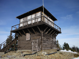
Tolmie Peak Lookout 11-27-2012

I Left the gate at 8:45 and started up the dry road. Snow showed up around 4000' feet and got as deep as 2-3 feet at the summit. Several others, including a few with snowshoes have made this trip since the bulk of the snow fell, a tightly packed trail to follow with little-to-no postholing. The overcast ceiling was well above Rainier and it was surprisingly warm compared to my recent trip to the Teanaway Valley. I used the Grindstone Trail to bypass the switchbacks in the road and before long I was looking at Mowich Lake.

 Some elevation was lost on the way up to Eunice Lake, which is completely frozen over. I was a little tempted to walk a short distance out, but being alone that would have been silly and dangerous. Even with the snow softening up a bit the short climb to the lookout tower and the true summit beyond it took less effort than I expected. 

Eunice Lake


 The tower has been shuttered for the season and the door sealed with a few nails but the back side luckily provided some decent shielding from the intense wind that seemed to begin as soon as I approached the top. Views were astoundingly clear in all directions. This was my first look at Mt St Helens since childhood. I dug around in the snow on the true summit for a register but had no luck, so after a few rituals I hurried back to the shelter of the lookout tower.


The true summit from the lookout


Trekking through Powder to Earl Peak 11-25-2012

I attempted this trip the day before with the dogs but 2 miles in I noticed their paws were bleeding from the sharp icy crust covering the snow. The N. Fork Teanaway river road is currently passable by low clearance vehicles at least to Beverly creek, where a few inches of snow have been rutted down to dry gravel. The road to Beverly Creek trailhead however is covered in snow and my tires are nearly bald, so I parked and walked from the junction.


My thanks to the folks with the snowshoes who broke trail up to Bean Creek, from there on the deep snow was mostly fresh powder that had me constantly sinking to my thighs, bot not consistently enough to get used to it. The naturally snow-trenched trail was relatively easy to follow but i left it after a sketchy re-crossing of Bean Creek, opting instead to ascend to the saddle between Earl Peak and Bean Peak before continuing to Earl's summit.

Alpenglow on Mary and Judy

Icy rock in Bean Creek


Clear skies the night before meant lower temperatures today despite the ever-present sun. It took me nearly 5 hours of hard work to finally reach the summit, but the cold prevented me from lingering too long. Stuart and the Enchantments looked as impressive as ever covered in a fresh blanket of white. Bean, Mary and Judy looked tempting as I hoped to have time to make a loop of them on the way back, but the deep powder had me set on a smoother return along my own tracks.

Just below Summit

Earl Peak
Mt Stuart and the Enchantments behind me

Mount Stuart


I enjoyed a few short glissades on the way down (video here) and then settled in for a long slushy return. Just past Bean Creek a lone pair of ski tracks appeared over my trail. I met the owner as he passed me on his way out about a mile from my car, the only soul I encountered all day.